The Rufiji Basin
The Rufiji River Basin is the largest river basin in Tanzania and in East Africa. It covers approximately 177,429 km2, or 20% of the total land area of Tanzania (URT, 2013a). Its elevation rises from 0 meters at the Indian Ocean to about 3000 meters in the Mbeya Region. The climate varies from tropical humid in the east to temperate in the Southern Highlands. It is drained by four rivers: the Great Ruaha, the Kilombero, the Luwegu and the Rufiji. The Ruaha and Luwegu Rivers join to form the Rufiji River that extends to the Indian Ocean.
Apart from being rich in water resources and biodiversity, the Basin is endowed with a good climate, fertile soil, minerals and human resource. It is known for it agricultural production and is often called the "bread basket" of Tanzania. Within the Basin, there are important national parks (Kitulo, Ruaha, Mikumi, Udzungwa and Uluguru), large game reserves (Selous, Rungwa, Usangu, Mpanga/ Kipengere, and Lunda), forest reserves, mining, and pasture for livestock.
The Basin covers 11 administrative regions and 26 districts. The Basin itself is managed by the Rufiji Basin Water Board under the Ministry of Water. Figure 1 illustrates the district administrative boundaries within the Basin.
Because of its large agricultural, hydroelectric and other potential, the Basin is the focus of Government of Tanzania, donor and private development plans. It has also attracted large numbers of people migrating to the area seeking land for cropping and to raise livestock. According to the national census, the Districts within the Basin had 9,032,089 people in 2012; this compares to 3,055,051 in 2002 (URT 2013b). Historical and projected future land use change is thus dynamic. Figures 2 though 4 illustrate projected land use from 2013 to 2050, taking into account past land use change patterns and projected population. The expansion of cultivation is assumed to be constrained to be within suitable agricultural areas and outside of protected areas (Olson et al. 2015).
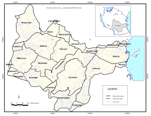 Figure 1: Administrative boundaries of the districts within the Rufiji River Basin. Source: IRA 2014.
Land Use Change
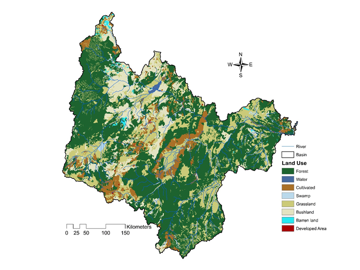 Figure 2: Land Use in 2013. Source: Olson et al. 2015.
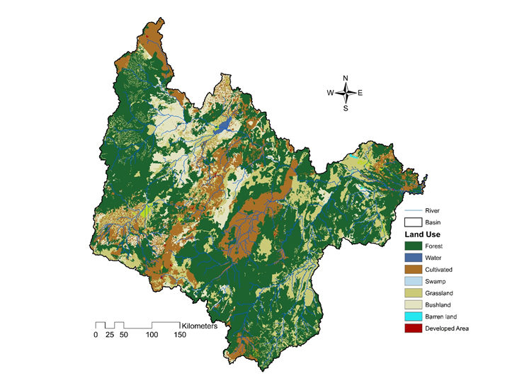 Figure 3: Land Use in 2025. Source: Olson et al. 2015.
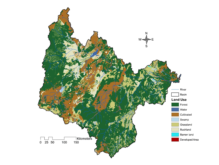 Figure 4: Land Use in 2050. Source: Olson et al. 2015.
References Cited
Olson, J., G. Alagarswamy, J. Andresen, N. Moore, W. Northcott, P. Miller, C. Hawkins, D. Pike and P. Morse. 2015. Analysis of the Impact of Climate Change on Crop and Water Availability, and Consideration of Potential Adaptation Practices for the Rufiji River Basin, Tanzania. Technical report submitted by Michigan State University to the University of Dar es Salaam for: "The Rice and Maize Resilience to Climate Change in the Rufiji Basin Project," October. 96 pp.
United Republic of Tanzania (URT). 2013a. National Population and Housing Census. Dar es Salaam, National Bureau of Statistics.
United Republic of Tanzania (URT). 2013b. Rufiji IWRMD Plan Final Report. Volume 1: Climate and Hydrologic Modeling and Assessments. Report prepared for the United Republic of Tanzania, Ministry of Water, by WREM International Inc., Atlanta, Georgia, USA.
Institute of Resource Assessment, University of Dar es Salaam (IRA). 2014. Milestone 1.4: Mapping Report. A Report Submitted to USAID Tanzania for “The Rice and Maize Resilience to Climate Change in the Rufiji Basin Project,” October. 54 pp.